Overview of Geophysics
Geophysics is the application of known physical principles to the study of the Earth. Terrestrial systems, like anything else, obey physical laws, and through applications of these laws quantitative predictions about the Earth’s present physical state and future evolution can be inferred. Geophysics, as a hybrid of geology and physics, requires awareness of the relevant geological issues and the ability to tackle them quantitatively. The principal tools of geophysics are seismology, heat flow and gravity analysis, magnetotellurics, and rock and whole-Earth magnetization. Each of these tools which can be brought to bear on a specific problem will yield constraints in terms of modelling, or understanding, a particular process or structure within the Earth.
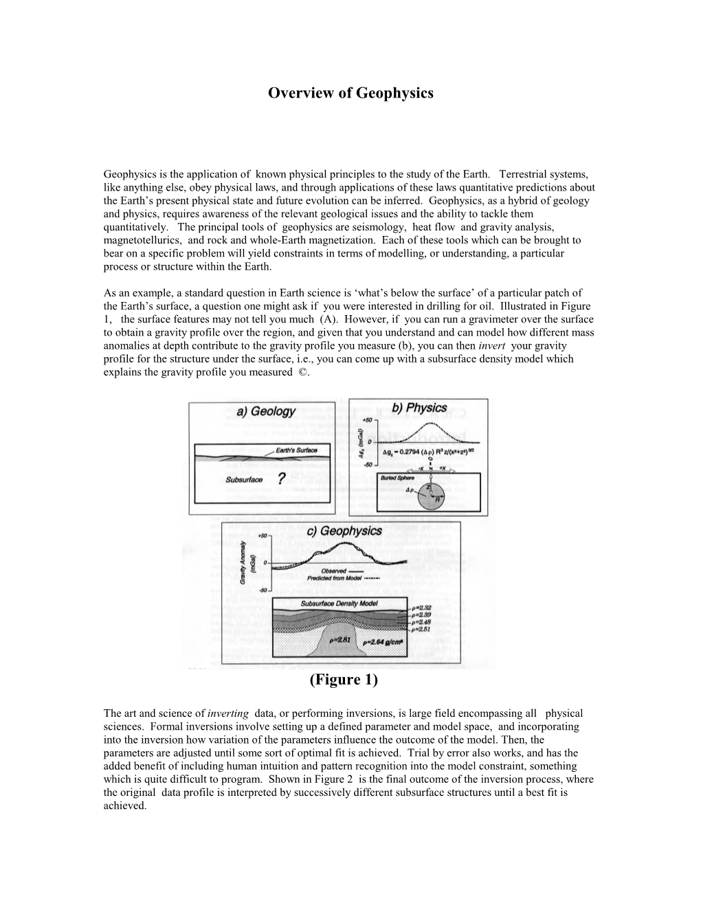
As an example, a standard question in Earth science is ‘what’s below the surface’ of a particular patch of the Earth’s surface, a question one might ask if you were interested in drilling for oil. Illustrated in Figure
1, the surface features may not tell you much (A). However, if you can run a gravimeter over the surface to obtain a gravity profile over the region, and given that you understand and can model how different mass anomalies at depth contribute to the gravity profile you measure (b), you can then invert your gravity profile for the structure under the surface, i.e., you can come up with a subsurface density model which explains the gravity profile you measured ©.
(Figure 1)
The art and science of inverting data, or performing inversions, is large field encompassing all physical sciences. Formal inversions involve setting up a defined parameter and model space, and incorporating into the inversion how variation of the parameters influence the outcome of the model. Then, the parameters are adjusted until some sort of optimal fit is achieved. Trial by error also works, and has the added benefit of including human intuition and pattern recognition into the model constraint, something which is quite difficult to program. Shown in Figure 2 is the final outcome of the inversion process, where the original data profile is interpreted by successively different subsurface structures until a best fit is achieved. Figure 2
Measurement Types
Seismology
Seismology is by far the most general and useful tools in studying subsurface structure, for many of the same reasons that your eyes are the most useful in discerning structure within a room. Seismology is the interpretation of seismic waves passing beneath a recording unit, or seismometer. These waves are shaped by features within the Earth’s interior, and by understanding how these waves are shaped, one can invert the waves for the structure which shaped them.
Figure 3
Figure 3 above shows three types of seismic techniques. Generally speaking, the deeper into the Earth you want to image, the further away from the earthquake you have to be, since deeper travelling waves surface at distances further from the earthquake source. For most deep Earth studies which address the structure of the mantle and core, the seismometers need to be located many thousands of Km from the earthquake. For local investigations, such as those designed around finding oil and gas, the refraction and reflection analysis use man-made sources to record waves reflected and refracted by layers under ground. These waves are then inverted for the structure of those layers, as illustrated in Figure 4.
Other large sub-fields of Seismology include seismic tomography, which is analagous to the medical field of computer axial tomography (catscans) , and encompasses using a wide array of earthquakes and sources to generate 3D models of the deep earth; seismic waveform modelling, which is the science and art of matching computed seismograms to the actual wiggles in the data; and Heat Flow
Heat constantly flows outward, from the hotter regions to the Earth’s surface. The change in temeperature
T can be measured from the surface downward in drillholes (Figure 5). The total energy or heat which flows out of a given area of the Earth’s surface is a function of the thermal conductivity (k) of the rocks beneath the area and the geothermal gradient below the area. Together, these can be used to calculate the rate at which thermal energy escapes from that region of the Earth, or the heat flow there. Without heat flow, the Earth’s interior would be completely solid and motionless; heat softens up a portion of the upper mantle, the asthenosphere; above this, movement of cold, rigid plates (the lithosphere) over this softer zone results from the heat flow.
Gravity and the Geoid
Earth’s gravity and magnetic forces are potential fields which provide constraints on the nature of materials within the Earth. Gravity’s strength and direction depnd on the position of the observation within the field; the strenth of the field decreases with distance from the source, ie, as one moves away from the Earth.
Overview of Geophysics