Climate Dynamics
Assessment of MPAS variable resolution simulations in the grey-zone of convection against WRF model results and observations
An MPAS feasibility study of three extreme weather events in Europe
Matthijs Kramer1,2 · Dominikus Heinzeller3,4 · Hugo Hartmann2 · Wim van den Berg2 · Gert‑Jan Steeneveld1
Received: 15 November 2017 / Accepted: 27 November 2018
© The Author(s) 2018
Abstract
Regional weather forecasting models like the Weather Research and Forecasting (WRF) model allow for nested domains to save computational effort and provide detailed results for mesoscale weather phenomena. The sudden resolution change by nesting may cause artefacts in the model results. On the contrary, the novel global Model for Prediction Across Scales
(MPAS) runs on Voronoi meshes that allow for smooth resolution transition towards the desired high resolution in the region of interest. This minimises the resolution-related artefacts, while still saving computational effort. We evaluate the MPAS model over Europe focussing on three mesoscale weather events: a synoptic gale over the North Sea, a föhn effect in
Switzerland, and a case of organised convection with hail over the Netherlands. We use four different MPAS meshes (60 km global refined to-3 km (60–3 km), analogous 30–3 km, 15–3 km, global 3 km) and compare their results to routine observations and a WRF setup with a single domain of 3 km grid spacing. We also discuss the computational requirements for the different MPAS meshes and the operational WRF setup. In general, the MPAS 3 km and WRF model results correspond to the observations. However, a global model at 3 km resolution as a replacement for WRF is not feasible for operational use.
More importantly, all variable-resolution meshes employed in this study show comparable skills in short-term forecasting within the high-resolution area at considerably lower computational costs.
Keywords MPAS · WRF · Numerical weather prediction · Grey-zone · Voronoi grid · Convection-permitting forecast ·
Hail · Föhn
1 Introduction
This paper is a contribution to the special issue on Advances in Convection-Permitting Climate Modeling, consisting of papers that focus on the evaluation, climate change assessment, and feedback processes in kilometer-scale simulations and observations. The special issue is coordinated by Christopher L.
Castro, Justin R. Minder, and Andreas F. Prein.
Many traditional numerical weather prediction (NWP) models, such as the Weather Research and Forecasting (WRF) model (Skamarock et al. 2008), are Limited Area Models
(LAMs), that require boundary conditions from larger scale models. These are generally provided by a global NWP model with relatively coarse grid spacing. This technique saves tremendous amounts of computational effort. However, that comes at a cost. These LAMs also use nesting, to bridge the gap from the coarse resolution of the global model, to the desired fine resolution required for their use case, e.g. mesoscale weather modelling (e.g. Wang et al.
2012). This nesting allows LAMs to zoom in step by step to
fine resolution, though with discontinuous grid size changes.
This nesting comes with certain disadvantages however.
In the smaller-scale domains, sub grid scale processes are
* Matthijs Kramer
mv.matthijs.kramer@gmail.com
1
Wageningen University, Meteorology and Air Quality
Section, PO box 47, 6700AA Wageningen, The Netherlands
2
Meteogroup, Research Department, Agro Business 99-101,
6708 PV Wageningen, The Netherlands
3
Institute of Meteorology and Climate Research,
Karlsruhe Institude of Technology, Kreuzeckbahnstr, 19,
82467 Garmisch-Partenkirchen, Germany
4
Institute of Geography, Augsburg University, Alter Postweg
118, 86159 Augsburg, Germany
Vol.:(0123456789)
1 3 M. Kramer et al. not explicitly resolved, but parameterised, and with the discontinuous grid size changes come parameterisation differences between domains, which is unnatural. The regional model domain size must be adequate to allow spatial spin-up of small-scale features from the lateral boundary conditions (Leduc and Laprise 2009; Leduc et al. 2011; Laprise et al. 2012; Steeneveld et al. 2015).
Furthermore, the parameterisation settings can differ between nested domains. Hence, the smaller domain can forecast a solution that does not match the solution of its surroundings, as determined by a larger domain. E.g., using WRF for a case study, Bukovsky and Karoly (2009) found that an inner domain shows up to 6 mm/day precipitation difference compared to its larger parent domain, over a period of 4 months (over 700 mm cumulative difference). This difference might be a result of numerical inconsistencies or of the parameterisation settings which are not scale adaptive. Obviously, the ratio between the resolved and parameterised contributions of the physical processes varies between domains. This may lead to overestimated precipitation intensity per event in domains with parameterised convection (Gadian et al. 2018). E.g. in various studies deep convection is not parameterised at grid spacing smaller than 3 km (e.g. Pennelly et al. 2014;
Pilon et al. 2016). A mother domain with a coarser resolution would then use a convection parameterisation, while an inner domain with finer horizontal resolution would not. In addition, numerous studies have tested regional models using various parameterisation setups (e.g. Jankov et al. 2005; Schwartz et al. 2010; Flaounas et al. 2011;
Klein et al. 2015). They found that no single combination of parameterisation works best in all cases, but large differences in precipitation rate and onset may occur.
Since MPAS is a global model, there are some trade-offs with respect to LAMs. A global model with the same resolution over an area of interest will have more grid cells than a LAM. Hence, MPAS involves massive computation time and output compared to regional models with similar settings.
However, MPAS has proven to be efficient on supercomputers, and as supercomputers are expected to use even more cores per node in the future, this efficiency will likely increase (Heinzeller et al. 2016), making MPAS a viable option for operational use on high-performance computing clusters. Also, it is worth mentioning that because of the approximately equal area grids, the issue of to reduced timestep to satisfy the computational
fluid dynamics’ condition for small grids near the pole, as in latitude/longitude grid is not required as in WRF. Another important aspect of MPAS is its promise for improved weather modelling. Currently, the MPAS model has mostly been optimised and extensively tested for tropical cyclones, regarding both meteorological output and computing efficiency, which incorporates modelling techniques and parameterisation schemes from the WRF model.
The current study aims to investigate the ability of the atmospheric core of the MPAS model (MPAS-A, henceforth
MPAS) to properly forecast various severe weather phenomena in Europe. To our knowledge, this is the first study where
MPAS is evaluated for mesoscale weather events in Europe: a synoptic gale event in north-western Europe, a föhn event in the Alps, and a case of organised convection in north-western
Europe. Previous studies focussed on Northern America or the lower latitudes (Landu et al. 2014; Heinzeller et al. 2016;
Pilon et al. 2016), and concluded that MPAS was capable of properly simulating the Intertropical Convergence Zone, the Western African Monsoon dynamics, and the Madden-Julian
Oscillation. Also, MPAS outperforms the GFS model score for tropical hurricanes in the Pacific (Davis et al. 2016). However,
MPAS has never been tested on the scale of a small European country (scale~300 km). This is also the first time that realcase forecasting experiments are conducted with a global 3 km mesh with more than 65 Mio grid cells. The model runs and post-processing of four 72-h forecasts with the 3 km mesh and the other MPAS meshes described below required several million CPU hours on a large HPC system (see details in Sect. 6).
The paper is organised as follows. Section 2 will give a short overview of the model settings. Sections 3, 4, and 5 evaluate the meteorological performance of MPAS for three test cases.
Section 6 discusses the runtime performance of MPAS, and conclusions are drawn in Sect. 7.
An alternative approach is using variable grid resolution models combined with scale-aware parameterisations. The Model for Prediction Across Scales (MPAS) uses Voronoi tessellations to create irregular multigonal grid cells around grid points, to create a global irregular grid (Skamarock et al. 2012). This allows smooth transitions from coarse to
fine resolution, in contrast to nesting techniques of traditional regional models. Moreover, MPAS does not need the usual grid transformation around the poles, which results in improved computational performance for global simulations compared to classic methods with a latitude-longitude grid with polar filters or spectral methods (Skamarock et al.
2012). This also requires certain parameterisation settings to be scale-aware, in particular for cumulus parameterisations.
In the version of MPAS used here, this is only implemented in the Grell-Freitas (GF) cumulus parameterisation. Scaleawareness for GF means first and foremost that the tendencies rapidly decrease as resolution increases. This process is described in Grell and Freitas (2013), and applied in MPAS by Fowler et al. (2016).
2 Models, data and methods
This study evaluates WRF and MPAS for three case studies: a synoptic gale case over the North Sea, a föhn case in Switzerland, and a case of organised convection with hail in the 1 3 Assessment of MPAS variable resolution simulations in the grey-zone of convection against…
Netherlands. This section discusses the model setups. For spatial evaluation, we use data from the European Centre for
Medium-Range Weather Forecasts (ECMWF) operational analysis at 0.125° resolution, which allows for evaluating the large-scale synoptic patterns against these pseudo-observations. Both models use the same land use map. One of the more important parameterisations is the planetary boundary layer (PBL) parameterisation. Both models use the MYNN
1.5 order TKE scheme (Nakanishi 2010). and up to ~ 30 km height. The selected parameterisations have earlier been optimised in-house for weather forecasting in Western Europe (see Table 1). In this setup, the cumulus parameterisation is disabled, as convection is supposed to be explicitly resolved at such fine resolution, although this discussion is still ongoing in literature (e.g. Gomes and Chou 2010; Krikken and Steeneveld 2012). The WSM6 microphysics parameterisation is a single-moment scheme and only predicts mass mixing ratios of the six water species (Hong and Lim 2006). In later WRF versions, a hybrid vertical coordinate system is supported, but not in version
3.6.1. As such, a terrain-following vertical coordinate system is used. Moreover, I/O quilting was used for the simulations 2.1 WRF setup
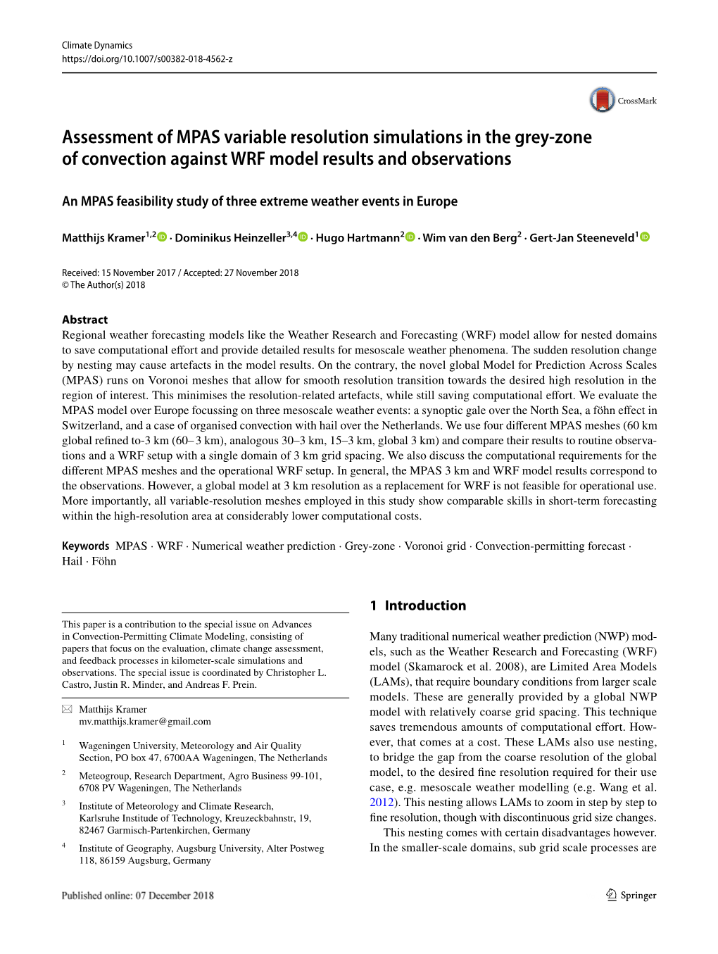
This study utilizes WRF version 3.6.1, with a setup consisting of one 3 km resolution domain, centred at 2.0°E, discussed here.
50.5°N. The model domain consists of 610×610 grid cells on a Lambert projection (Fig. 1). A single domain was preferred to avoid previously discussed artefacts by domain nesting, and to approach the resolution of initial conditions.
WRF uses ECMWF operational forecast at 0.125°×0.125° horizontal resolution as initial conditions and boundary conditions. This is the resolution closest to WRF’s 3 km, so artefacts due to downscaling of initial and boundary conditions are expected to be minimal. The WRF model utilises
39 vertical eta levels, concentrated in the lower troposphere
2.2 MPAS setup
Here, we evaluate an unreleased version of the MPAS model
(version 4.0), which includes a scale-aware GF convection scheme that becomes less active as grid cell size decreases.
The model also includes the Thompson microphysics scheme that is able to cooperate with the scale-aware GF scheme.
Both options have been included in the MPAS 5.0 release.
Additionally, this version includes the SIONlib I/O layer for
Fig. 1 Resolution refinement of the MPAS 60–3 km mesh (left), the MPAS 15–3 km mesh (middle), and the domain of the WRF model
(right). The WRF model has a single domain and a 3 km resolution throughout the domain. The refinement area for the MPAS 30–3 km is identical to the MPAS 60–3 km mesh
Table 1 Parameterisation
Microphysics WSM6 Hong and Lim (2006)
Parameterisation WRF scheme MPAS scheme settings for both models
Thompson Thompson et al. (2004)
–Cumulus Grell-Freitas (scale-aware) Fowler et al. (2016)
Longwave radiation RRTMG Price et al. (2014)
Shortwave radiation RRTMG Iacono et al. (2008)
Boundary layer MYNN Nakanishi (2010) MYNN Nakanishi (2010)
Surface layer MYNN Nakanishi (2010) MYNN Nakanishi (2010)
RRTMG Price et al. (2014)
RRTMG Iacono et al. (2008)
Land-surface NOAH Ek et al. (2003) NOAH
1 3 M. Kramer et al. improved I/O performance (Heinzeller and Duda 2017). We evaluate the MPAS model for three global grid configurations: a first grid that refines from 60 km over the globe to
3 km over Europe, a second grid that similarly refines from
15 to 3 km, but with a larger 3 km area (this grid was already used in experiments for the CONUS region), and a third grid with a uniform resolution of 3 km (Fig. 1). The global
MPAS grids utilise initial conditions from ECMWF forecast data with a spatial resolution of 0.25°× 0.25°. This is an intermediate resolution between the coarsest (60 km) and finest (3 km) resolutions on the MPAS grids. The number of grid cells varies largely for the different configurations between 8.36 × 10⁵ (60– 3 km), 6.49 × 10⁶ (15–3 km) and 65.5×10⁶ (3 km). For comparison, the nested domain of the WRF setup corresponds to 3.74×10⁵ grid columns.
For each case, the MPAS model was initialised either at
00UTC or 12 UTC. For each case, the initialisation time and naming convention for the model runs will be specified. We use 15-min output intervals for the 60–3 km and 15–3 km mesh, and 30-min output for the global 3 km mesh.
3 Synoptic gale
3.1 Case description
On October 27th 2013, a depression over the North Sea with associated frontal systems caused heavy winds throughout north-western Europe. On October 28th, the cold front passed over the Netherlands accompanied by wind gusts of up to 42 ms−1 at the coast. Across Europe the storm resulted in power outages in several hundred thousand households and millions of euros in damages. The transportation sector was seriously affected by the extreme winds (Wadey et al. 2015; Staneva et al. 2017), and eventually 21 casualties have been reported. Obviously correct forecasting of such an event is crucial. For this case, we use five different
MPAS setups and a single WRF setup. We use all MPAS grid meshes, and for the 60–3 km and 30–3 km meshes we also evaluate MPAS for two initialisation times. Model runs notations have been listed in Table 2 and will be used in the following sections of this section.
All MPAS grids use 55 vertical levels up to ~ 30 km height, while WRF employs 39 levels up to a model top of 50 hPa. The selected parameterisations are mostly similar to WRF, though notable differences have been listed in
Table 1. The utilized MPAS employs the scale-aware GF cumulus parameterisation, which means that the tendencies rapidly decrease as resolution increases. Currently, the GF scheme is the only cumulus scheme with this functionality.
The Thompson microphysics scheme was selected since it is unique in its cooperation with two other parameterisations.
First, Thompson microphysics has been successfully tested with the scale-aware GF scheme. Second, the Thompson microphysics scheme is uniquely coupled with the RRTMG radiation scheme concerning information about cloud droplet size distributions. We therefore consider this the most consistent approach to modelling of cloud physics. The MPAS version of the Thompson scheme used in our study is very similar to the WSM6 scheme used in the WRF setup.
Both the WSM6 microphysics scheme used in the WRF model and the Thompson microphysics scheme use 6 water species. However, where WSM6 is a single-moment scheme and only determines mass mixing ratios of the precipitation species, Thompson adds another moment for rain, i.e. the number concentration, as a prognostic variable (Thompson maximum wind speed. et al. 2004). Sensitivity tests with the WRF model using the Thompson microphysics scheme provided approximately similar results as with the WSM6 scheme. Other parameterisation schemes that are identical are applied the same in MPAS as they are in WRF.
3.2 Forecast performance
3.2.1 Forecasting the synoptic situation
First, we compare forecast pressure maps on October 28
2013, 06UTC from both models to the ECMWF operational analysis, which is used as pseudo-observations since observations have been included in the data assimilation process.
Next, we analyse the minimum pressure (not necessarily occurring at the same time and location) and the associated The variable-resolution MPAS runs perform similar to the global 3 km MPAS run for the late initialisation time 28_00
(Fig. 2b–g; Table 3). In the earlier initialised run 27_12
(Fig. 2b, d; Table 3) the depression is pushed out to the east over the North Sea. This shift is even more pronounced in the 27_12 WRF run (Fig. 2h; Table 3). The 27_12 WRF run places the core more than 300 km off the ECMWF 28_00 analysis, and closest to continental Europe and the Dutch coast. The MPAS 60–3 km and 30–3 km 27_12 runs begin to shift the core westwards towards the ECMWF analysis
(~200 km distance). All MPAS 28_00 runs place the core within less than 60 km of the analysis. The core pressure is similar for the WRF 27_12 run, the MPAS 28_00 runs and the ECMWF analysis. The earlier MPAS 27_12 runs show
In contrast to WRF, MPAS uses a hybrid vertical coordinate system by default. While this may make the model comparison less straightforward, both vertical coordinate systems have their advantages and disadvantages. E.g. the terrain-following coordinate system can be easily coupled to the boundary and surface-layer parameterization schemes
(Schär et al. 2002). On the other hand, numerical errors can occur around steep slopes (Steppeler et al. 2002), which is minimised when using a hybrid vertical coordinate system.
1 3 Assessment of MPAS variable resolution simulations in the grey-zone of convection against…
Table 2 Model setup for each
Model Grid resolution Initialisation time model run for the 2013 synoptic gale case
60–3 km 30–3 km 15–3 km 3 km 27 Oct. 12UTC 28 Oct. 00UTC variable variable variable
MPAS 60–3 km 27_12 XX
MPAS 60–3 km 28_00 XX
MPAS 30–3 km 27_12 XX
MPAS 30–3 km 28_00 XX
MPAS 15–3 km 28_00 XX
MPAS 3 km 28_00 XX
WRF 3 km 27_12 XX
a slightly deeper core (973 hPa versus 975–977 hPa), which, in combination with the location of the core being closer to the continent, leads to slightly higher wind speeds along the following the experience of European forecasters. Therefore, we first search for the time and location where the depression reached its lowest pressure. We limit this search to the Dutch coast. North Sea and the Netherlands, from 53.0 to 55.0°N and 5.00–7.00°E, within a time period from 07 UTC to 10 UTC for the earlier 27_12 runs, and from 09 to 12 UTC for the other runs, including the WRF run. This difference in time window was specified to account for the easterly dislocation of the earlier MPAS runs. Subsequently, we search for the highest wind speeds around this point and time. As such, we define an area 180 km to the south and 120 km to the west of the minimum pressure location. These dimensions are chosen empirically with the area of interest (southern
North Sea) in mind. Within this box, with a margin of 1.5 h around the time of minimum pressure, we search for the The easterly shift in the low-pressure core is also present in the operational ECMWF analysis (not shown). Hence, the agreement between the model runs and the forecasts in positioning the low pressure system at 06 UTC is largely determined by the initialisation time.
The uniform MPAS 3 km run in this case does not improve over the considerably cheaper variable resolution runs. Contrary to the variable-resolution meshes, this uniform-mesh run does not employ a scale-aware cumulus parameterisation. Hence, for this test case, we conducted a sensitivity experiment with the uniform 3 km mesh in which the cumulus parameterisation was switched on. The results highest wind speeds. are almost identical to the run without the scale-aware GF scheme (not shown). This confirms that the scale-aware
GF scheme is mostly inactive at a resolution of 3 km, i.e. also in the high-resolution area of the variable-resolution meshes. This is shown in more detail in Sect. 5.2.2, where both resolved and parameterised precipitation are shown All forecasts locate the low-pressure centre over the North
Sea, to the north of the Netherlands (Fig. 3; Table 4). All
MPAS runs are located at almost the same latitude further north than the analysis, whereas the longitude varies with initialisation time (earlier runs are further to the West) and the with the mesh employed. The WRF 27_12 run positions separately. the lowest pressure close to the ECMWF analysis. The earlier initialised runs all forecasts the lowest pressure 2–3 h too early for both WRF and MPAS.
3.2.2 Forecasting wind characteristics
Interestingly, the ECMWF analysis shows the wind maximum to the east of the depression, which may be a result of the data assimilation performed by the ECMWF on the operational forecast (Fig. 3; Table 4). There is little variation in the location of maximum wind speed between the WRF and MPAS runs, as they have this location clustered.
Assessment of MPAS Variable Resolution Simulations in the Grey-Zone of Convection Against WRF Model Results and Observations