Year 11 Geography Revision List – Key Geographical Themes
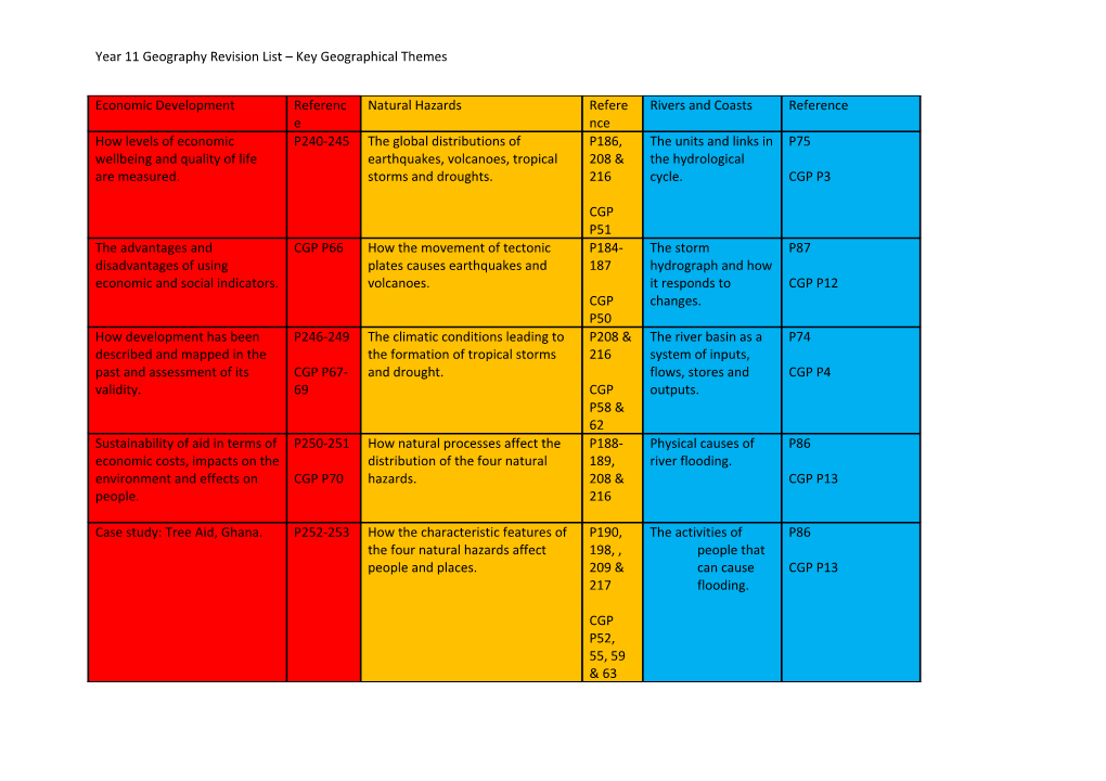
Economic Development / Reference / Natural Hazards / Reference / Rivers and Coasts / ReferenceHow levels of economic wellbeing and quality of life are measured. / P240-245 / The global distributions of earthquakes, volcanoes, tropical storms and droughts. / P186, 208 & 216
CGP P51 / The units and links in the hydrological cycle. / P75
CGP P3
The advantages and disadvantages of using economic and social indicators. / CGP P66 / How the movement of tectonic plates causes earthquakes and volcanoes. / P184-187
CGP P50 / The storm hydrograph and how it responds to changes. / P87
CGP P12
How development has been described and mapped in the past and assessment of its validity. / P246-249
CGP P67-69 / The climatic conditions leading to the formation of tropical storms and drought. / P208 & 216
CGP P58 & 62 / The river basin as a system of inputs, flows, stores and outputs. / P74
CGP P4
Sustainability of aid in terms of economic costs, impacts on the environment and effects on people. / P250-251
CGP P70 / How natural processes affect the distribution of the four natural hazards. / P188-189, 208 & 216 / Physical causes of river flooding. / P86
CGP P13
Case study: Tree Aid, Ghana. / P252-253 / How the characteristic features of the four natural hazards affect people and places. / P190, 198, , 209 & 217
CGP P52, 55, 59 & 63 / The activities of people that can cause flooding. / P86
CGP P13
How employment structures vary between countries. / P264-265
CGP P73 / Understanding he nature of primary and secondary effects. / P190 / Case study: Flooding in Cumbria, UK, 2008 / P88-91
How employment structures have changed over time and may change in the future. / P266-267 / Comparing the impact of natural hazards in LEDC and MEDC places, using GIS as well as data and evidence. / P210-213 / Case study: Flooding on the Zambezi, 2009 / P92-95
The types of industry (primary, secondary, tertiary and quaternary) and the economic and environmental locational factors for each. / P254
CGP P74 & 78-79 / Case study: Haiti Earthquake, 2010 / P192-193 / Use of GSI, new technologies, aerial photographs and data to highlight flood management schemes and their effectiveness. / P94-95
The environmental, social and economic reasons why the location of economic activity changes. / CGP P77 / Case study: Japan Earthquake, 2011 / NOTES IN EXERCISE BOOKS / How weathering, erosion, transport and deposition operate in a river basin. / P78-79
CGP P5-9
Case study: Palm Oil, Indonesia. / P256-257 / Case study: Hurricane Katrina, USA, 2005 / P212-213 / The formation of fluvial landforms, including meanders, interlocking spurs, floodplains, river cliffs, valleys and waterfalls. / P80- 85
CGP P5-9
Case study: Call centres, Newcastle, UK / P260-261 / Case study: Cyclone Nargis, Burma, 2008 / P210-211 / Case study: River Derwent / P77
What an MNC is and the reasons for globalisation. / P268-269
CGP P85 / The reasons for people living in hazardous areas. / P224-225 / How weathering, transport and deposition operate along constructive and destructive coastlines. / P96-105
CGP P17-22
The positive and negative effects of MNC investment in an area. / CGP P86 / How settlement and economic activities affect the impact of natural hazards events. / P217 / The formation of landforms along a stretch of coastline, including cliffs, headland, cave, arch, stack, beach and spit. / P100-105
CGP P17-22
Case study: Shenzhen, China or Nike in Vietnam / P270-271 / How building, planning and education methods are used. / P196, 215 & P222-223
CGP P53, 56 & 64 / Case study: Jurassic coast / P96
The possible future for globalisation and its effects on specific groups of people. / P274-275 / Prediction methods and how they work. / P197, 206-207 & 214
CGP P53, 56 & 64 / Human and physical reasons why the protection of coastlines is necessary. / P106-107
CGP P24
A range of ways to show how economic activities affects the physical environment. / CGP P88 / Use of GIS, new technologies and satellite images to map distributions and patterns of natural hazard events. / P206 & 214 / Different methods of coastline protection and sustainability of each including groyne, offshore breakwater, sea wall, rip rap, revetment, gabion, beach replenishment and managed retreat. / P108-111
CGP P25
Use of GIS, new technologies and satellite images of analyse economic activity and environmental conflict and areas where it is occurring. / P276 / The sustainability of these methods in terms of their economic costs, impact on the environment, effects on people most at risk. / P196-197, 206-207, 214-215 & P222-223 / Case study: Coastline management at Poole Bay. / P112-115
The need to balance environmental concerns and the need for economic development. / P280-281
Case study: Deepwater Horizon Oil Spill / P276-277